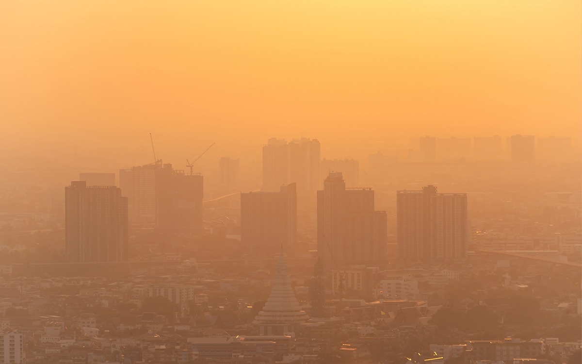
Hazy skies. Low-hanging clouds. Air that feels uncomfortable, and is often risky to breathe.
This summer, much of the East Coast and Midwest regions of the United States have been experiencing what people living on the West Coast have come to expect: diminished, dangerous air quality due to wildfires. In late June 2023, over 120 million Americans were living under air quality warnings, with the cities of Chicago, Detroit, and Milwaukee having some of the worst air quality in the entire world.
Behind this summer’s bad air is a rash of wildfires in Canada which have burned an unprecedented 25 million acres—a giant area the New York Times describes as “roughly the size of Kentucky.” The fires are record-setting, surpassing the Canadian fires of 1989, which burned over 18 million acres. And they have turned deadly, killing two Canadian firefighters and displacing more than 120,000 people. Extreme heat and dry, windy weather are to blame for the early and severe wildfire season.
Coal dust continues to build up on neighbors’ cars and their houses, staining their siding black.
While areas of the United States from New York City to Georgia to Montana have been impacted by the 2023 fires burning in Canada, some American communities have been struggling with air quality for generations.
Industrial pollution impacts places like South Baltimore’s Curtis Bay neighborhood, which sits across the street from the Curtis Bay coal terminal, the second largest coal exporter on the East Coast. At the CSX Transportation Coal Piers, giant mounds of coal, primarily from the Appalachian region, wait to be exported across the globe.
In late 2021, an explosion at CSX due to an accident broke windows in Curtis Bay homes and spread a layer of coal dust over the neighborhood. Two years later, coal dust continues to build up on neighbors’ cars and their houses, staining their siding black. As David Jones, who lives in the Curtis Bay neighborhood, told NPR, “You wake up in the morning and your throat hurts.”
“Jones is one of millions of people in the United States who live with dangerous air pollution, including gases like nitrogen oxide and sulfur dioxide, ground-level ozone and tiny particulates that coat every surface,” as NPR reported. “Some particles are so small they worm deep into the lungs and cross into the brain.”
Despite a community lawsuit, ongoing protests, and hefty fines from the Occupational Safety and Health Administration for violating worker safety, CSX continues operating in South Baltimore. The soot keeps piling up, and residents have reported black flecks in their saliva. The neighborhood also experiences diesel pollution due to heavy truck traffic going to and from CSX.
“My whole house is black,” Jones said to NPR. Fellow Curtis Bay resident Tiffany Thompson told Baltimore public radio station WYPR she always keeps a pair of shoes by her front door, in case there’s another industrial accident and she and her children have to run.
The Limits of Tracking Air Pollution from Land
“Clean air is invisible. But sometimes polluted air is, too.”
Air pollution disproportionally impacts poor communities and people of color. Those areas of the country with poor air quality before the Clean Air Act was passed in 1970 —including southeast Texas and Rust Belt areas of the Midwest and Northeast—still struggle with pollution today.
Sign up for our free newsletters
Subscribe to NPQ's newsletters to have our top stories delivered directly to your inbox.
By signing up, you agree to our privacy policy and terms of use, and to receive messages from NPQ and our partners.
Air pollution has been linked to emphysema, to other respiratory issues such as chronic obstructive pulmonary disease, and to both the development and worsening of asthma. Children in low-income, urban areas are more likely to have asthma attacks than children living in other areas. But part of the problem with dealing with air quality is that it’s historically been difficult to monitor and track.
This summer’s wildfires have turned the air visibly smoky at times, but that isn’t always the case. According to Resources, “Clean air is invisible. But sometimes polluted air is, too—even according to the network of monitors in the United States that’s specifically designed to tell us what we can’t see.”
Land-based monitors to study air pollution can’t pick up everything, and they aren’t located everywhere, by far. As Wired reported, “Seventy-nine percent of US counties lack an Environmental Protection Agency monitor on the ground, so the EPA’s information isn’t representative of the air most Americans are breathing.”
How can more air be monitored more effectively? One way is from space.
Real-Time Monitoring
Tropospheric Emissions: Monitoring of Pollution (TEMPO, for short) is a new satellite instrument, the product of a collaboration between NASA, the National Oceanic and Atmospheric Administration (NOAA), and the Smithsonian Astrophysical Observatory. TEMPO is designed to provide nearly continuous air pollution readings about the entire country.
“We could be using satellite data to create a more comprehensive view of which communities across the country are overburdened by pollution.”
Launching in late August of 2023, TEMPO will be attached to a commercial telecommunications satellite in constant view of North America. According to the project’s website: “By measuring sunlight reflected and scattered from the Earth’s surface and atmosphere back to the instrument’s detectors, TEMPO’s ultraviolet and visible light sensors will provide spectra of ozone, nitrogen dioxide, and other elements of daily atmospheric chemistry cycles.” In other words, it will register pollution.
“We could be using satellite data to create a more comprehensive view of which communities across the country are overburdened by pollution,” Susan Anenberg, director of the Climate and Health Institute at George Washington University Milken Institute School of Public Health, told NPR, describing the satellite as “a major advance.”
The information from TEMPO will be relayed in real time, which is essential for studying how air quality can change at different points in the day, such as when more diesel trucks are driving through a neighborhood or when trains pass through. The satellite may also be an important tool for alerting the public about ever-changing air quality when wildfires or other chemical disasters make going outside dangerous.
Residents of polluted areas, like people living in Curtis Bay, know that data is an important tool in making the air in their communities safer. Data is evidence in their ongoing fight for clean air, and some Curtis Bay neighbors have been working with researchers from Johns Hopkins University to install air monitors near their homes. The data from TEMPO will provide an even fuller picture of air quality.
Thompson moved to Curtis Bay because she needed stable housing after a cancer diagnosis in her family. “We have grown to love our community,” she told WYPR. But every time she looks at the coal plant across the street, she can’t help but think about “those things that are definitely polluting our air. Mounds and mounds of things that pollutes the air.”